Archive

Over the years, RACMO has been applied to Antarctica, Greenland and some other glacierized regions for different time periods. Below is an overview of the different regions we studied and what model version we used. The most recent runs for which data is available are listed on our data site (link).
RACMO2.3
Antarctica
Name: |
RACMO2.3p3 ANT27XX |
|
Resolution: |
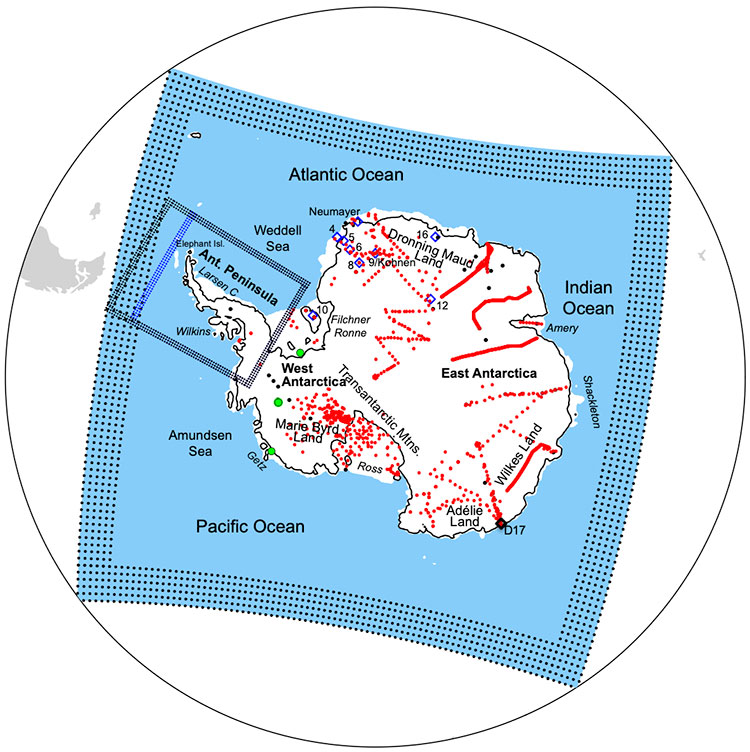
27.5 km (0.25°), 262 x 240 points, 40 levels | |
Domain: |
Antarctic continent | |
Period: |
1979-2018 | |
Forcing: |
ERA5 | |
Key publication: |
|
Name: |
RACMO2.3p2 ANT27 |
 |
Resolution: |
27.5 km (0.25°), 262 x 240 points, 40 levels | |
Domain: |
Antarctic continent | |
Period: |
1979-now | |
Forcing: |
ERA-Interim / ERA5 | |
Key publication: |
|
Name: |
RACMO2.3p2 ANT27XX |
|
Resolution: |
27.5 km (0.25°), 262 x 240 points, 40 levels | |
Domain: |
Antarctic continent | |
Period: |
1950-2015, 2015-2100 | |
Forcing: |
CESM historical, SSP1-2.6, SSP2-4.5 and SSP5-8.5 | |
Key publication: |
Name: |
RACMO2.3p1 ANT27/2 |
 |
Resolution: |
27.5 km (0.25°), 262 x 240 points, 40 levels | |
Domain: |
Antarctic continent | |
Period: |
1979-2014 | |
Forcing: |
ERA-Interim | |
Key publication: |
|
Name: |
RACMO2.3p1 ANT5.5/DML |
 |
Resolution: |
5.5 km (0.05°), 456 x 330 points, 40 levels | |
Domain: |
Antarctica Dronning Maud Land | |
Period: |
1979-2012 | |
Forcing: |
ERA-Interim | |
Key publication: |
|
Name: |
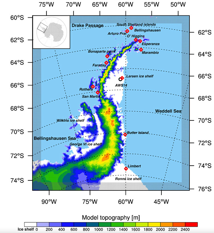
RACMO2.3p1 ANT5.5/Pen |
 |
Resolution: |
5.5 km (0.05°), 330 x 294 points, 40 levels | |
Domain: |
Antarctic Peninsula | |
Period: |
1979-2013 | |
Forcing: |
ERA-Interim | |
Key publication: |
|
Greenland
Name: |
RACMO2.3p1 GRIS11/3 |
 |
Resolution: |
11 km (0.1°), 306 x 312 points, 40 levels | |
Domain: |
Greenland Ice Sheet | |
Period: |
1979-2014 | |
Forcing: |
ERA-Interim | |
Key publication: |
|
Ice Caps
Name: |
RACMO2.3p1 PAT5.5 |
 |
Resolution: |
5.5 km (0.05°), 330 x 254 points, 40 levels | |
Domain: |
Patagonian Ice Fields | |
Period: |
1979-2013 | |
Forcing: |
ERA-Interim | |
Key publication: |
|
RACMO2.1
Antarctica
Name: |
RACMO2.1 ANT27 |
 |
Resolution: |
27.5 km (0.25°), 262 x 240 points, 40 levels | |
Domain: |
Antarctic continent | |
Period: |
1979-2013 | |
Forcing: |
ERA-Interim | |
Key publication: |
|
Name: |
RACMO2.1 ANT5.5/TAD |
 |
Resolution: |
5.5 km (0.05°), 306 x 306 points, 40 levels | |
Domain: |
Antarctica Terre Adèlie land | |
Period: |
2009 | |
Forcing: |
ANT27 | |
Key publication: |
|
Name: |
RACMO2.1 ANT5.5/PTW |
 |
Resolution: |
5.5 km (0.05°), ?? x ?? points, 40 levels | |
Domain: |
Antarctica Pine Island/Twaites glacier area | |
Period: |
1979-2013 | |
Forcing: |
ERA-Interim | |
Key publication: |
|
Name: |
RACMO2.1 ANT55/ECH |
 |
Resolution: |
55 km (0.5°), 134 x 122 points, 40 levels | |
Domain: |
Antarctic continent | |
Period: |
1980-2099 | |
Forcing: |
ECHAM5, A1B + E1 scenarios | |
Key publication: |
|
Name: |
RACMO2.1 ANT55/HAD |
 |
Resolution: |
55 km (0.5°), 134 x 122 points, 40 levels | |
Domain: |
Antarctic continent | |
Period: |
1980-2199 | |
Forcing: |
HadCM3, A1B + E1 scenarios | |
Key publication: |
|
Greenland
Name: |
RACMO2.1 GRIS11/2 |
 |
Resolution: |
11 km (0.1°), 306 x 312 points, 40 levels | |
Domain: |
Greenland Ice Sheet | |
Period: |
1960-2011 | |
Forcing: |
ERA-40 + ERA-Interim | |
Key publication: |
|
Name: |
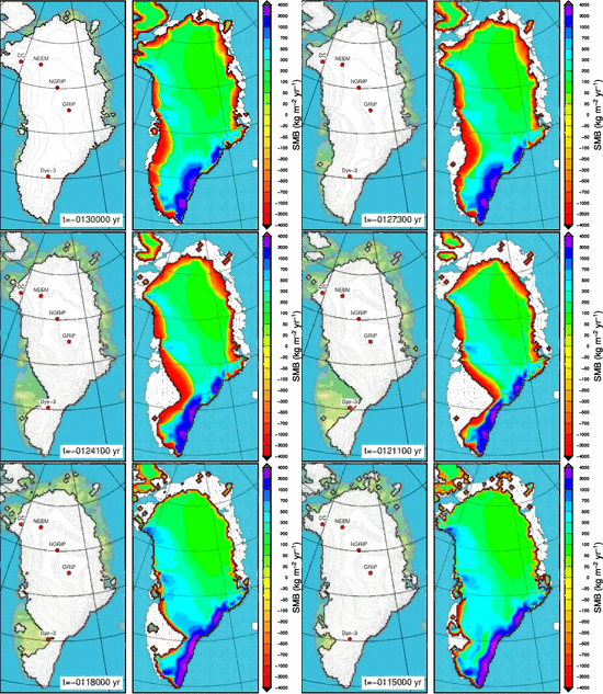
RACMO2.1 GRIS18/EEM |
 |
Resolution: |
18 km (0.165°), 206 x 264 points, 40 levels | |
Domain: |
Greenland Ice Sheet | |
Period: |
Eemian, 30 year | |
Forcing: |
ECHO-G | |
Key publication: |
|
Name: |
RACMO2.1 GRIS18/PRE |
 |
Resolution: |
18 km (0.165°), 206 x 264 points, 40 levels | |
Domain: |
Greenland Ice Sheet | |
Period: |
Pre Industrial, 30 year | |
Forcing: |
ECHO-G | |
Key publication: |
|
Name: |
RACMO2.1 GRIS11/FUT |
 |
Resolution: |
11 km (0.1°), 306 x 312 points, 40 levels | |
Domain: |
Greenland Ice Sheet | |
Period: |
1971-2100 | |
Forcing: |
HadGEM2-ES, RCP4.5 scenario | |
Key publication: |
|
Name: |
RACMO2.1 GRIS11 |
 |
Resolution: |
11 km (0.1°), 246 x 312 points, 40 levels | |
Domain: |
Greenland Ice Sheet | |
Period: |
1958-2008 | |
Forcing: |
ERA-40 + ECMWF operational analyses | |
Key publication: |
|
Ice Caps
Name: |
RACMO2.1 CAN11 |
 |
Resolution: |
11 km (0.1°), 306 x 312 points, 40 levels | |
Domain: |
Canadian Arctic | |
Period: |
1960-2011 | |
Forcing: |
ERA-40 + ERA-Interim (from 1989 onwards) | |
Key publication: |
|
RACMO1
Antarctica
Name: |
RACMO1 ANT55 |
 |
Resolution: |
55 km (0.5°), 122 x 130 points, 20 levels | |
Domain: |
Antarctic continent | |
Period: |
1979-1994 | |
Forcing: |
ERA-15 | |
Key publication: |
|
Name: |
RACMO1 ANT14 |
 |
Resolution: |
14 km (0.13°), ?? x ?? points, 20 levels | |
Domain: |
Antarctic Peninsula | |
Period: |
1980-2199 | |
Forcing: |
ERA-15 | |
Key publication: |
|
